Best of Breed Solutions within reach - For your Geospatial needs
Home : What we do : GIS Services : GIS & Remote sensing
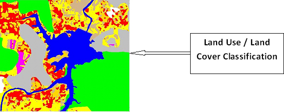
GIS & Remote sensing in natural resources mapping
We provide our GIS services in
At Zeta Softech we offer accurate geo-coding / geo- referencing and are capable of various Analytical procedures for different users in Agriculture, Fisheries, Telecom, Electrical, water supplies, Market Research, Utilities, Oil & Gas Industry, Crime Mapping, Flood Management or Hazard mitigation.
At Zeta Softech we provide high quality Mapping and Geo-spatial solutions to meet the demands and needs in the field. We specialize in precision conversion services in areas such as architectural plans, ground cadastre and topographic maps, distribution networks for utilities such as electricity, gas & water networks, facility plans, site survey plans and civil & mechanical engineering drawings. Our services include re-drafting, digitization, vectorization database development and programming.
The Company is focused to meet the customer requirements through deployment of competent experienced technical manpower with state of art infrastructure.

Our GIS team, with a skilful thematic mapping service, helps you display the spatial distribution of a single attribute or a specific topic, such as property assessments, soil types, or crime locations.
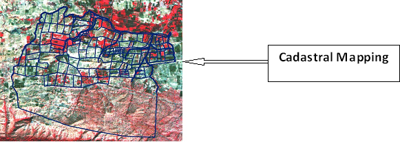
We help you in the process of cadastral mapping and change detection studies. We also provide 3D visualization and modeling services for hydrological, geochemical, hydro-chemical or any other custom applications.
We specialize in utility mapping which consists of many different services including full system digitization, system modeling, land base creation, revisions, work order updates, circuit map creation, and raster to vector map conversion.
We can add utility information to your digital base plans and design drawings. This is convenient foe customers, knowing precisely where utilities are located through the enhanced detail of digital composite underground utility maps. Cost reductions and safety enhancements can be realized during the design and construction phases of a project by comprehensive mapping of all underground infrastructures with geophysical technology. These data are captured and registered to existing site survey plans to provide situational control. Digital documentation of the underground is presented as easy-to-read drawings.
Our state-of-the-art conversion techniques provide our customer with a one-stop Data conversion facility for AM/FM/GIS/LIS data. Our techniques include raster to vector conversion; manual digitizing, operator-assisted tracking, post-vectorizing data cleaning and normalization, automatic generation of polygons, coordinate system conversion, rubber-stretching. We develop productivity tools to enhance quality and quantity of our outputs.
Zeta Softech provides data conversion services, both in graphics and non-graphics (text & numeric) into leading databases, GIS, AM/FM, CAD and word-processing formats.
Our quality procedures involve multiple color plots at different stages of production, manual & on-screen cross-check of electronic files against source documents and utilization of automated quality tools & routines.

Email : info@zetasoftech.com
Call us : 0712-2240594
0712-2249801
Skype : msw.zil
Yahoo : malswa2003@yahoo.com


