Best of Breed Solutions within reach - For your Geospatial needs
Home : What we do : GIS Services : GIS For Oil and Gas industry
Geospatial information has become the key to the interpretation and decision making process in the Oil and gas industry. From finding an apt location to drill a well to routing the pipelines from the exploration site to the refinery, a good comprehension of the geographic details becomes an essential part as intelligent business decisions heavily rely on these information.
The geographical data provide information like the presence of oil in a particular region, the mining distance, whether oil is present or not etc. The region is also sealed, if no further mining is needed there.
We can deliver GIS services spanning various stages of project development including:
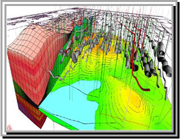
Petroleum Exploration: Petroleum exploration demands a thorough understanding of different data such as satellite imagery, digital aerial photo mosaics, seismic surveys, surface geology studies, subsurface and cross section interpretations and images, well locations, and existing infrastructure information. GIS combines these data together to the location in question which allows you to view, overlay and manipulate the data in the form of a map to analyze the potential for finding new or extensive potentials in detail.
GIS programs can be utilized to monitor the condition and flow of pipelines and determine the best pipeline locations to transport oil off the fields and to the refineries.
Production: For the proper functioning of the found reserves, the company must initially identify certain geographic, infrastructural, business and environmental factors about the area in question. Innovative GIS technology is ideally suited for the overlay analysis which can be integrated to other business risk/economic business planning engines to provide a focused business solution tool set.
Managing Facilities: Due to the global nature of the petroleum industry an unmanageable and complicated infrastructure has evolved. It is essential for large, integrated oil companies to keep track of every minute detail from drilling platforms to pipeline networks and to refineries for their efficient management and advancement in this highly competitive business area. Geospatial information can be aptly used to map the transmission of products to a facility. Once this process is accomplished, integration with more traditional "in-plant" infrastructure management systems, such as CAD, attribute records, and scanned documents, allow the true geographic placement of CAD entities complementing the CAD architecture.
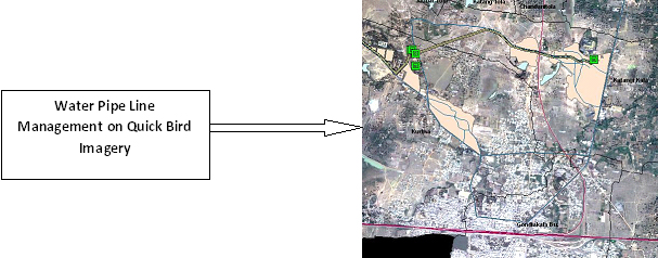
Pipeline Management: An in-depth analysis and study of geographical locations, business requirements, and managed utilization of resources helps the creation and management of a functional pipeline network. This helps achieve optimal productions and efficient processes for movement of crude and refined oil from petroleum reserves to refinery, and then to storage units respectively. GIS is also used for the site location process, and helps to minimize environmental impacts during construction, accidental release as well as to minimize the costs of liability risks associated with accidental releases.


Email : info@zetasoftech.com
Call us : 0712-2240594
0712-2249801
Skype : msw.zil
Yahoo : malswa2003@yahoo.com


